How Do We Know?
Land Survey Records
Public Land Survey records are an important source of information on the character of the vegetation in Illinois prior to European Settlement. These records have been used to reconstruct pre-European settlement (or native) vegetation in many states including Wisconsin (e.g. Cottam, 1949; Curtis, 1959; Ward, 1956), Minnesota (e.g. Grimm, 1981), Michigan (Bourdo, 1956), and Indiana. In Illinois, Anderson (1970) used land survey records to map the location of prairies and forests in the state in the early 1800’s. Other studies include those by Kilburn (1959), who used used land survey records to map the prairie-forest border in Northeastern Illinois, and Moran (1978), who described the pre-settlement vegetation of Lake County, Illinois, using land survey records made from 1837 to 1840.
Many of the land surveys conducted in the original thirteen colonies were not standardized. These early surveys included little information on vegetation or other natural features (Hutchison, 1988). The need for a more systematic and reliable land survey grew with westward expansion following the Revolutionary War. The federal government needed a way to parcel out and describe the location of lands for sale to settlers, and the settlers needed to be able to accurately locate and document their claims (see Clement, 1958). In 1785, the Continental Congress of the United States established the General Land Office through which land was sold, and the Office of the Surveyor General which was responsible for surveying the land. A new plan for locating, describing, and parceling out lands was devised. Thomas Jefferson was a member of the commission that prepared this plan, which stipulated that lands be surveyed prior to settlement and that the surveys be conducted in a consistent and standardized manner. In 1786 another act of Congress directed that territory was to be surveyed into townships, six-miles square, which were bounded by lines running true north and south, and east and west. Each township was to be divided into 36 sections, one square mile each, by lines running north, south, east and west. The sections were numbered from one to thirty-six. Instructions to surveyors directed them to describe vegetation and the general character of the land they surveyed in greater detail.
Most of Illinois was surveyed between 1804 and 1856. Daniel Miller and D. A. Spaulding, Jr. surveyed six townships encompassing the Midewin National Tallgrass Prairie in 1821 and 1834. These surveys include mention of an “Old Indian Boundary," a Potawatomi dwelling, and a survey of lands reserved for a Potawatomi chief.
When a deputy surveyor contracted with the government to survey land, he hired a crew consisting of one or more axemen, flagmen, chainmen, and sometimes others. The surveyors were responsible for the accuracy of the equipment, which included a compass (and later a solar compass) and the chains used to used to measure the distance between township and section corners. The surveyors measured distances in chains and links. There are 80 chains to the mile, and 100 links to the chain (a chain is 66 feet long and a link is 7.92 inches). In order to mark the regular grid system of townships and sections on the ground, the surveyors usually placed a post at each township and section corner, as well as at quarter-section corners halfway between the section corners. To help locate the post, or in the event that the post was destroyed, the surveyors blazed “witness” trees near the post in forested areas or built an earth mound with trenches around the post in prairie. The surveyors recorded all or some of the blazed trees in their notebooks, and these are known as bearing trees. It is these bearing trees that are so valuable to modern-day ecologists for reconstructing the vegetation at the time of the survey. Bearing trees were not a random sample of the forest trees, however. Surveyors chose them based on size, proximity to the corner post, and probability of long-life, as the purpose of a bearing tree was to help relocate the corner in the future. However, in any area the choice of trees was limited, and the trees recorded were in fact there. The surveyors recorded the bearing trees by common name (e.g., “black oak”), diameter in inches, distance from the corner post in links, and compass bearing from the post. They also described the vegetation after each survey mile or sometimes half-mile.
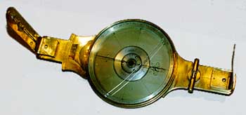 |
| Abraham Lincoln's surveying compass Robert Church Located in the collection of New Salem State Historic Site |
At the Midewin National Tallgrass Prairie, the groves and upland forested areas were dominated by oaks, (white oak, black oak, burr oak) prior to European settlement, with black walnut, hickory, hackberry, basswood, elm, and some sugar maple. In some areas where the forest was more open, an understory of hazel and sometimes vines occured. The surveyors recorded hazel undergrowth in the areas occupied by Star Grove and in a small section of Hoff Woods (Glass, 1994).
When surveyors entered stretches of treeless prairie, they erected mounds of earth in which a post was placed to mark section and quarter-section corners. The mounds were cut from the prairie sod, which was stacked, layer upon layer, in a pyramid-type arrangement, to a height of 3 feet (McLain, et al., 1997). When a post was not set into the mound, sometimes large stones or charcoal were buried within it. Once again, they provided a general description of the land after surveying each section line. In the prairies, descriptions were often brief, for example, "Land prairie, gently rolling, 2nd rate."
Next | Back